Sydney is a vast city and you will definitely need Sydney
maps to be able to get around. There are many static
maps of Sydney that we show on this page.
However, as mobile technology kicks in coupled with the
GPS tracking system, you can use and download Sydney
maps on your mobile phone to locate your location down
to 1 meter accuracy.
The Global Positioning System (GPS) is free satellite
system that enables GPS or Mobile phones such as iPhone
which has built-in GPS tracking software to locate the
position within 1 meter accuracy.
You can buy a GPS tracking system with all Australian
cities in it for around 200-600 dollars. Alternatively, you
can use you iPhone or Nokai mobile phone and use Google
earth or Google maps to find locations in Sydney.
Sydney roads are also listed in books that you can buy
from gas station. Though this is as cheap as 30 dollars, it
is an old fashion you'd reckon!
We explore all of these options on this page of Sydney
maps for you. You will find the static maps of Sydney on
the right hand side. Just download these to your local
desk or mark this site on your browser when you visit
Sydney.
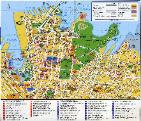
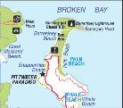
We list 14 Sydney maps below:
2- Sydney suburb map
3- Sydney suburbs Maps 6MB (PDF) takes a while to
download
4- Detailed Sydney map including Hotel locations
maps to be able to get around. There are many static
maps of Sydney that we show on this page.
However, as mobile technology kicks in coupled with the
GPS tracking system, you can use and download Sydney
maps on your mobile phone to locate your location down
to 1 meter accuracy.
The Global Positioning System (GPS) is free satellite
system that enables GPS or Mobile phones such as iPhone
which has built-in GPS tracking software to locate the
position within 1 meter accuracy.
You can buy a GPS tracking system with all Australian
cities in it for around 200-600 dollars. Alternatively, you
can use you iPhone or Nokai mobile phone and use Google
earth or Google maps to find locations in Sydney.
Sydney roads are also listed in books that you can buy
from gas station. Though this is as cheap as 30 dollars, it
is an old fashion you'd reckon!
We explore all of these options on this page of Sydney
maps for you. You will find the static maps of Sydney on
the right hand side. Just download these to your local
desk or mark this site on your browser when you visit
Sydney.
We list 14 Sydney maps below:
2- Sydney suburb map
3- Sydney suburbs Maps 6MB (PDF) takes a while to
download
4- Detailed Sydney map including Hotel locations
Free Sydney Maps for you... |